A commercial building is one that is
dedicated to commercial activities. The technical classification of a
commercial building for zoning purposes is that it has more than half of its
floor space used for commercial activities.
·
Basics
An alternative definition of a commercial
building is a structure that is not used for residential or civic functions.
Various retailers and other businesses lease space in commercial buildings in
order to operate without buying a property.
·
Owners
Commercial buildings are owned by various
individuals and group entities who construct them or build them for profit.
Developers build commercial properties with the intent to resell for profit or
to lease for income. Other investors enter after construction for similar
investment purposes. Some commercial buildings are developed by organizations
for company operations.
a) FORMAL
·
SERVICES
Ø A
service is something that the public needs, such as transport, communications
facilities, hospitals, or energy supplies, which is provided in a planned and organized
way by the government or an official body.
·
ACCOMMODATION FACILITIES
Ø Accommodation
facilities means a dwelling, building or individual units, where the majority
of facilities are shared and where a maximum of 10 rooms housing not more than
16 guests, are leased on a short-term basis (maximum 21 days) and may include
catering facilities for guests that stays overnight, but does not include
self-catering facilities.
·
PERSONAL AND HOUSEHOLD SERVICES
Ø Personal and household
services cover jobs and services carried out to support households. 63% are
care activities: childcare, assistance to the elderly, dependent or disabled,
excluding healthcare, and 37% are non-care activities: cleaning, laundry, meal
preparation, gardening, small house repairs and private lessons. The activities
of care and non-care are highly intertwined. While non-care support allows
people to spend more time caring for their parents or children and care support
generally includes a large component of non-care.
·
PETROL STATION
Ø The
gas station is typical premises that provide the refuelling of petrol, diesel
and NGV for motor vehicle.A petrol station that sells only electric energy is also known as
a charging station.
·
BANK
Ø A
bank is a financial institution that creates credit by lending money to a
borrower, thereby creating a corresponding deposit on the bank’s balance sheets.
·
RETAIL
Ø Retail is the process of
selling consumer goods or services to customers through multiple channels of
distribution to earn a profit. Retailers satisfy demand identified through a
supply chain. The term "retailer" is typically applied where a
service provider fills the small orders of many individuals, who are end-users,
rather than large orders of a small number of wholesale, corporate or government
clientele.
·
SHOPPING COMPLEX
Ø A shopping mall,
shopping center/centre, shopping arcade, shopping precinct, or simply mall is
one or more buildings forming a complex of shops representing merchandisers,
with interconnecting walkways enabling visitors to easily walk from unit to
unit, along with a parking area.
·
RESTAURANT
Ø A Restaurant is an
establishment offering varying types and levels of service, including a meet
and greet service and serving food and beverages in a designated eating area.
If the restaurant chooses to serve alcohol it must have an alcohol license. A
restaurant must have a sub-brand which indicates the type of food served.
·
WHOLESALE
Ø Wholesale is the
activity of buying and selling goods in large quantities and therefore at
cheaper prices, usually to shopkeepers who then sell them to the public. Wholesale
also means that a business buys goods in large quantities directly from
manufacturers or distributors, warehouses them, and resells them to other
businesses. Due to high-volume purchase orders, those in wholesale are
typically able to buy products at a lower price and add their margins.
Wholesale supply means that customers can purchase products at a good price.
b) INFORMAL
COMMERCIAL
·
NIGHT MARKET
Ø A Night Market is a
grouping of temporary outdoor stalls operated by petty traders where products
are displayed for sale. The night market popularity steamed from the
convenience they provided for the local residents to do shopping for their
household needs within their residential areas.
·
TEMPORARY STALL
Ø A temporary stall is a
retail facility erected and operated for a special event or activity and
completely dismantled upon its conclusion.
·
Booth
(static)
Ø Stall
is informal business activities that exist in urban centres, neighbourhood centres,
residential areas, industrial areas and institutions that sell a variety of
goods, drinks and food static stalls/ booths groups built outside of the food
court. The site is limited especially in the city centre or built together with
the bus stop or on a private lot.
·
Booth
(mobile)
Ø Hawker
can move easy to another business either using caravans
Ø The
night markets, weekend markets and farmers ‘markets are clustered in one area
vend a big number.
·
Open
café
Ø Open
café concept provides an overview of the atmosphere is relaxed, modern, formal
and quality. Features that distinguish between the facilities are open café and
kiosk.
·
Arcade/bazaar
Ø Arcade
/ bazaar are a business premises housed in a covered alley or in the building
that houses the business activities of small-scale and informal nature.
3.2.2 Existing Commercial Land Use
 |
Image 3.5 : The overall zone for Commercial
|
Kuah Town has 2 categories of commercial types such as
formal and informal commercial, Total area of the commercial area is 15.88 % of
the site. it is divided into several commercial types which are:-
 |
| Image 3.6 : The percentage of commercial in study area |
3.2.3 Commercial in Zone 1
 |
Image 3.7 : Zone 1 for commercial area
|
Types
of commercial in zone 1 are more like accommodation facilities, retail and
personal and household services because this area are surrounded by village.
3.2.4 Commercial in Zone 2
In
zone 2 there are lots of commercial types because this area is a town centre
fon kuah town.
 |
| Image 3.8 : Zone 2 for commercial area |
3.2.5
Commercial in Zone 3
In zone 3 also have the same situation with zone
3 but not crowded as it
 |
Image 3.9 : Zone 3 for commercial area
3.3 PUBLIC
FACILITIES
Public facilities can be defined as an
essential elements in providing a basic human needs, like recreation, safety,
health, education and worship. For instance public facilities that include
police stations, health care, mosque and fire station. Public facilities
provide the convenient and efficient services, sense of identity, and defined
from the character of city Kuah, Langkawi. The analysis of user need for public
facilities actually based on their demand, the characteristics of the user
population, the location of services, cost, operate and maintain the services.

Public facilities and services in each
zone, mostly in zone 2 has many public facilties which is 18 units. There are
local point as a community facility which is a Jetty Kuah in zone 1. In zone 2,
public facilities such as, police station, fire rescue station and school. The
public facilties buildings majority in good condition and mostly enough. Also
it is easy to access because close to main road and secondary road (Persiaran
Putra, Jalan Padang Matsirat and Jalan Ayer Hangat).
3.3.2 Types of Public Facilities
a) Education
There are 5 educational facilities in Kuah
Town:-
Image 3.10 : The locations of Public Facilities in Kuah town
Table 1 shows the information the schools
facilities in Kuah Town. This education is easy to access through Persiaran
Putera, Padang Matsirat Road and Ayer Hangat Road. Mostly schools is located in
zone 2. The schools should be located on streets that have a parallel bicycle
lanes or paths based on the guidelines that proper design for community users
so they can bike their bicycle to schools while reducing the uses of vehicle.
The condition of buildings education majority is in good condition but in the
future may need to investigate the physical condition of each school facility,
both internal and external, and identified which schools required improvements
based upon age and the cost of renovation and may need to provide a new
instituition
b) Security
The public safety facilities mostly located
in zone 2; Fire and Rescue Hall, Langkawi Police Headquarters and Langkawi
Traffic Police Station. In Kuah Town there are two Fire and Rescue Hall in zone
2 close to Persiaran Putera and Ayer Hangat Road. Community police stations
should be located to all communities which they are required serve near to
residential. So that emergency vehicles easily to dispatched. The security
facilities was distribute on emergency vehicles (main road), visible and
accessible to people. Basically, the security facilities is enough for Kuah
Town but in the future may need to upgraded or rebuild follow the community
population and their needs.
Photo 3.1 : Langkawi Police Headquater
c) Health
In
the Kuah Town there is a public facility which is health clinic that located in
Zone 2, that clicin is 13.17 acres and located in the same road with police
station and school. There are also hospital facilities but are outside the zone,
which means that communities in zone 1 are likely to feel distant for access to
health centers
Photo 3.2 : Health Clinic, Langkawi
d) Cementry
There are 2 cemeteries in Kuah City, namely
Islamic Cemetery (Zone1) and Chinese Cemetery (Zone2). Cemeteries are generally
not considered to be suitable land uses residential use. In general, the
facility have an issues that the path way
to the Chinese cemetery has a dirty drainage issue with no cleaning that will
cause the drain to clog and in the future this faclilities also may
need to additional land.
e)
Religious
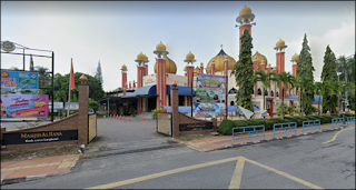
There are 6 religious facilities in Kuah
Town, 4 mosque, 1 church and 1 temple; Al-Hana Mosque, Al-Qadim Kuah Mosque,
Langkawi Chinese Methodist Church, India Langkawi Mosque, Kelibang Mosque and
Sri Subramaniam Temple. The location of this facilities will generally depend
on the community being served and the existing facilities in the area
surrounding the site. Mosque are generally community facilities and should be
located within walking distance for members.
Photo 3.3 : Al-Hana Mosque, Langkawi
f)
Sport Facilities
Sport facilities located in zone 2; Langkawi
Mini Stadium and Langkawi Sport Complex. This facilities are closed to schools
buildings and provided to encourage the public to actively participate in sport
to shape a healthy and active community. Based on the observation, this
facilities is just enough but in the future as the population may increased so
it will need to renovate
3.4 INFRASTRUCTURE
AND UTILITIES Infrastructure
and utilities is a basic facilities and services which facilitates different economic
activities and there help in economic development of the country. The types of
infrastructure such as road, drainage and sewerage. For utilities such as
electrical supply, water supply, telecommunication and solid waste management. Infrastructure
and utilities is importance facilities to provide in the study area. Provision
of infrastructure and utilities is one of the aspect that are important and
need to be considered in any development. Infrastructure and utilities are the
basic requirement needed by each individual. A systematic and comprehensive
planning for the development of infrastructure and utilities is essential to
ensure the scheme in line with economic development such as residential,
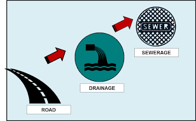
commercial and industry. 3.4.1 Infrastructure Infrastructure
is the fundamental facilities and systems serving a country, city or other
area. Infrastructure including the services and facilities necessary for
economy to function. Infrastructure is composed of public and private physical
improvement such as road, drainage and sewerage Diagram 3.1 : Type of Infrastructure a) Road A
road is a throughfare, route or way on land between two places that has been
paved or otherwise improved to allow travel by foot or some form of conveyance
including a motor vehicle, car, bicycle and buses. Road consist of one or two
roadways, each with one or more lanes and any associated sidewalk and road
verge. There is sometimes a bike path. Other names for roads include parkways,
highways or primary, secondary and tertiary local roads. · State The federal road is a major road network
connecting major cities and towns in the Langkawi district. This federal road
also connects state roads located in the Langkawi district. The main federal
roads available in Langkawi district are Federal Highway 110, Federal Highway
112, Federal Highway 113, Federal Highway 114, Federal Highway 115 and Federal
Highway 116. The federal roads consists of four lanes with
dividers and two lanes without dividers. Other federal roads consists of four
lanes with dividers and two lanes without dividers. Other federal roads within
Langkawi Districts are as follows : Ø
Federal
Road 104-105 Federal Road 164 Ø
Federal
Road 107-108 Federal Road 166-168 Ø
Federal
Road 110-120 Federal Road 272-273 Ø
Federal
Road 151-162 Federal Road 278 ·
Federal State roads are roads
maintained by the State Government through the State Department of Public
Works. Generally, the state road in Langkawi District is a two-lane road
without a road divider with an average road width of less than 20 meters. State
road located in Langkawi District is State Road K197. ·
Local Local Roads are urban, residential,
industrial and rural areas outside the responsibility of the State Public Works
Department. Local roads are roads that are under the control of local
authorities or land and district offices. Local roads serve as support roads
serving rural and urban areas. b) Drainage System Drainage and drainage systems throughout the
Langkawi District are operated by Department of Irrigation and Drainage (DID).
DID's main task is management rivers, flood management and eco-friendly
drainage. DID ensures that each the rivers in Langkawi are clean and meet the
standards of hygiene clarity of river water. 60% of Langkawi District's water
supply depends on the supply from the Plant New River Water Treatment in
Perlis. Increased demand for water supply the future will depend on the supply
through the seabed pipe from Peninsula. Several major river basins have been
identified in the Langkawi District supply local water. c) Sewerage System Sewerage
system in Langkawi is under supervision Indah Water Konsortium Sdn Bhd (IWK).
The scope of the service is to provide and monitor local treatment plants. The
field of work also provides services and develops a sewerage system in Langkawi
with a modern and more efficient sewerage system for the residents in Langkawi. The
IWK also need to oversee the catchment area for sewerage operations. It is the
responsibility of the authorities to ensure that their capacity is always at a
higher level than the current use of any sewage plant in Langkawi. The IWK also
need to make sure the sewer pipe is in good condition in the event of damage or
leakage during the sewer pipe, the IWK must resolve the matter promptly. 3.4.2 Utilities Utilities mean useful features or something
useful to home and some place such as electrical supply, water supply,
telecommunication and solid waste management. a) Electric Supply The electrical power supply system is one of
the most important fields in the development area especially in the
residential, commercial and industrial areas to facilitate development
activities and daily life. In Langkawi state, electricity supply is fully
regulated by Tenaga Nasional Berhad (TNB) and is also major supplier of
electricity in Peninsular Malaysia. Therefoe, it is TNB indirect responsibility
to ensure that electricity is supplied to every area at a reasonable rate.
Electricity is provided through the transmission line (ETL), Main Distributor
(PPU), and Feeder Piller (PE). Main entrance (PMU) and the main distribution
(PPU) with coverage area in Langkawi Island : Table 3.1 :Type of Infrastructure
b) Water Supply Syarikat Air Darul Aman Bhd (SADA) a company
are responsible for managing the water supply throughout the Langkawi District.
There are two water sources for the Langkawi area from the Langkawi and the
water supply source from the peninsular are connected through the 38km
underwater pipes from Kuala Sungai Baru, Perlis to the Kuah, Langkawi. Table 3.2 : The design and production capacity of water plant.
The source of the water supply from the Kuala
Sungai Baru, Perlis is under control of a consortium Taliworks Langkawi Sdn Bhd
(TLSB) appointed by the state of government under the privatization of water
supply. The purpose of this agreements it to provide a source of treatment
water supply to the people in Langkawi and treat water for SADA to re-supply to
the local residents. c) Telecommunication Telecommunication and ICT systems are one of
the basic needs of the industry daily life. Telecommunication and ICT systems
are also known as fixed or mobile and broadband. Services mobile is limited as
competition grows. Telecommunication used for a number of purposes such as
domestic use, usability industry and public concumption. The telecommunication
system is integrated and effective is required to support the connection
between urban and rural areas cities include fixed line, mobile phone service
and even internet connection includes providing telecommunication towers. At Kuah District telecommunication and ICT is
provided by Telekom Malaysia (TM) and TELECOS Cellular. This infrastructure is
also covered by cellular phone Direct Exchange Lines (DEL), TM internet
(STREAMYX), 2G/3G/4G and the latest 5G internet Cellular. Monitoring of each
telecommunication and ICT is done by Communication and Multimedia Commissions
(MCMC) throughout Malaysia. Other companies that also provide services to
telecommunications systems and ICT such as Telekom Malaysia, Celcom, Maxis
Communication Bhd, Digi.Com.Bhd, Umobile. Unifi and so on. The photo shows the
existing telecommunication in study area. d) Solid Waste Management Solid waste is a any scrap material or other
unwanted surplus substance or rejected products rising from the application of
any process. Solid waste can be defined as the useless and unwanted products in
the solid state (liquid, semi-solid or containerized gaseous materials) derived
from the activities and discarded by society. Solid waste management is a term that is used
to refer the process of collecting and treating solid waste. It also offers
solutions for recycling items that do not belong to garbage or trash. Waste
management is all about how solid waste can be changed and used as a valuable
resources. Solid waste management should be embraced by each and every
household including the business. Trade management disposal is managed by
MPLBP. The waste disposal method used in Langkawi area is the open-landfill.
This area are receives 100-120 tan of waste every day from all Langkawi. The
site disposal are about 70 acres including hill area.
|
3.4 GOVERNMENT BUILDINGS
Government
building defined as building that house a branch of government. It also means a
building which is owned, possessed, or used by or leased to the state, or any
of its political subdivisions. Building government is a structure that has a
roof and walls and stand more a less permanently in one place. Government
building is important to enhance state or district services.
There are 16 elements of government building in Kuah
town such as Langkawi Courthouse, Correctional Academy of Malaysia and Majlis Perbandaran Langkawi Bandaraya
Pelancongan. There are 3 government building at zone 1 and same goes to
zone 3, while 10 elements at zone 3. Mostly the government building can be
found at zone 2 because most business activities are conducted in this area. It
is cover 3.18% of site area. The government building in Kuah is easy to access
because it is located near to residential and commercial area. It is also
located near to main road in Kuah. For example, Langkawi Development Authority
(LADA) building are located near to Persiaran Putera.
3.4.1 Goverment Building Characteristics
a)
Building Condition
Building condition is very important to support
decision making and it is also critical to the management in achieving the
service standards for maintenance. Good building condition is the building is
safe for used, the paint is still in good condition and no need repair. Most of
the building condition in Kuah are in good condition. For instance, the
Langkawi Development Authority (LADA) are I n good condition because it is a
new building, no defect, and active building.
b)
Building Materials
Building material is any material that is used for
construction purpose. Many naturally occurring substance, such as clay, rocks,
sand and wood, even twigs and leaves, have been used to construct buildings.
The main material that is used for government building construction in Kuah is
brick. Brick is the most common used man-made material on earth because brick
material is strong and stable. People are choosing brick as the building
materials because of it compressive strength. Timber material also found for
government construction in Kuah. For example, Correction Academy of Malaysia
building are made with brick and timber.
c)
Building Structure
Building structure refers to anything that is
constructed or build different interrelated parts with a fixed location on the
ground. Based on observation, all of the government building structure in Kuah
is permanent.
d)
Building Distribution
Distribution of government building in Kuah are
dispersed. It is located far from each other which cannot reached by walking
and mostly the government building be central in zone 2. There are 3 elements
of government building in zone 3 and same goes to zone 1 only 3 elements while
10 elements in zone 2. The government building have a good accessibility
because it is located near to main road in Kuah. Besides, it also closed to
residential, commercial and recreational area.
3.5 BROWNFIELD AND GREENFIELD AREAS
a)
Brownfield
According to EPA and the new federal brownfields law
(known as the Small Business Liability Relief and Brownfields Revitalization
Act), brownfields are "real property, the expansion, redevelopment, or
reuse of which may be complicated by the presence or potential presence of a
hazardous substance, pollutant, or contaminant." In other words,
brownfields can be any abandoned, idle, or under-used industrial or commercial
facility where reuse is complicated by real or perceived environmental contamination.
Brownfields come in all shapes and sizes, from closed
steel mills or vast watersheds contaminated by mining contamination, to vacant
corner gas stations, abandoned grocery stores, or old town dumps. What all
brownfields have in common is that real or perceived contamination can cause
fear in those who may otherwise be willing to put these sites back into use —
fear of costs, complications, delay, or even legal liability associated with
the pollution. These perceptions can discourage the private sector from buying
these sites, block local governments from getting involved at these sites,
raise concerns among lenders and financiers, and otherwise chill activity at
brownfields.
Yet, brownfields are not hopeless places —and in fact
they are often prime locations for revitalization. Brownfields are often
located on favorable real estate, such as waterfronts, central city areas, or
places that are nearby to other businesses and resources. Brownfields typically
have infrastructure already in place.
Mostly, in Pusat Bandar Kuah there are some of commercial buildings which are abandoned.
· In Pekan Rabu, there are some underutilized buildings that need to do some redevelopment as the buildings are abandoned.
· In Taman Mawar, many of the commercial at these area are in underutilized.
· There are 3 area that were classified as Brownfield:
a) Pusat Bandar Kuah
b) Pekan Rabu
c) Taman Mawar
b)
Greenfield
Greenfield development represents the
"expansion" form of urban growth. Greenfield is a favoured form of
housing development by many for its relative simplicity and often cheaper land
costs. They are also favoured where there is a desire for a visible,
large-scale "project", as large parcels of land are typically easier
to consolidate (approach adopted by JDA).
The definition of greenfield development generally
encompasses non-productive land, habitats and productive farmland on the urban
periphery (fringe development). In the Housing and Employment Land Supply
Program Report (Department of Planning and Local Government, 2010) this is also
commonly referred to as ‘broad acre’ land development which is generally
located on the fringe of the metropolitan area or near township.
According to Jim Heid, is greenfields, unconstrained by
surrounding land uses, large and easy to assemble and afford, allow developers
to plan comprehensively and build efficiently. Here on the edge, saving open
land, building modern and sustainable infrastructure, and creating diverse and
livable communities can still be done right. To be sure, the suburban ideal has
shifted from escaping the city to creating a new “edgeless” regional form—where
city and country mutually benefit from one another.
The Sierra Club
defines sprawl as “the expansion of low density, automobile-dependent
development that occurs at the fringe of the urban landscape.” Isolating land
uses and lacking transportation alternatives, sprawl forces long car trips to
schools, employment, stores, and community activities. Combining homogeneous,
economically segregated housing with formless public space, sprawl’s generic
look seems to suppress anything local or special.
The area that had been identified as greenfield consists of the undeveloped agricultural areas.
· In the future these greenfield areas can provide a range of affordable housing and a range of housing types to meet a variety of needs and preferences.
· Mostly greenfield areas in Kuah,Langkawi are classified as undeveloped agricultural and vacant land.
· It can be conclude that there are 3 area that were classified as greenfield:
Ø Jalan Beringin
Ø Kampung Kuah
Ø Kampung Bakau