by: Mohammad Syazani bin ShaifulRizal, Mohd Hafizi bin Haron, FarahNorizwani binti Nordin
TRANQUIL LINKAGES CITY
PEKAN KUAH, LANGKAWI

INTRODUCTION
Connectivity is the primary purpose of any transportation network. it links locations people want to travel between. In order to improve the image and use of land space from current planning, space connection, from one place to another, must be improved to connect people.
PLANNING GOAL
To create an integrated orderly town by capitalising the connectivity nodes with core area.
PLANNING VISION
The vision of Pekan Kuah is making Kuah Town as a peaceful interconnected island town with core area.
OBJECTIVES
- Preparing alternative conceptual plan based on overall site findings to improve sustainability, mobility, and economic opportunity.
- To revitalize certain places such as local park and commercial area by adding aesthetical value to become more vibrant.
- To establish an interconnected system that connect the community together through a hierarchy of open spaces and to ease the access from Jetty to the core area in Kuah's Town.
1. Lack of parking spaces
- There is a traffic congestion at the entrance of jetty Pekan Kuah because of a lot of rental car are park
2. High demand for affordable housing
- The percentage of housing is less than commercial area.
- With a high percentage of B40 income group, it is hard for them to afford decent quality housing especially when there is a lack in supply for affordable housing in Pekan Kuah.
3. Demand for hotels, resort and homestays
- Pekan Kuah is an attention for tourist to stays, so there is a high demand for homestay, resort and hotels
CONCEPT IDEA

This mean that each element that have been highlighted in proposed site area is inter - connected to each other via road, pedestrian path or even green linkages.
|
Connectivity refers to the directness of links and the density of connections in a transport network Connectivity concept can be idealized like a travel demand modeling that generally assigns a cost to travel that includes the "cost" of time. All else being equal, shorter travel times are preferred. This is particularly true for bicycling and walking, which are usually slower than motorized travel.
As connectivity increases, travel distances decrease and route options increase, allowing more direct travel between destinations, creating a more accessible and resilient transportation system (TDM Encyclopedia, 2009). Increased network connectivity can reduce travel distances for all modes, including walking and bicycling. An additional benefit of increased connectivity for these modes is having a wider range of routes from which to choose.
 |
| The bubble concept |
 |
| The connectivity concept in bubble diagram |
Connectivity affects more on the degree of transportation
network such as streets, walking and cycling track in order to connect the
people to their destinations. A good connectivity actively seeks to discourage
car use by making local trips easier and more pleasent just by walking rather
than using a car.
 |
| The transportation activities by walking and cycling |
Transportation activity by walking or cycling is positively
associated by number of destinations and public transport and perceived access
to bike lanes near home (Hoehner et al, 2005). The presence of well-maintained footpath
is associated with walking for recreation and for transport (Pikora et. Al,
2006). In Pekan Kuah, the pedestrian need to be upgrading in all aspects which
is design and safety aspects in order to encourage more people using the
pedestrian path. The connectivity for between the land use in Pekan Kuah need to
be created systematically to shorten the travel distance from one place to
another.
The diagram below show how
connectivity works between a ten minute (800 metre) pedestrian catchment in an
area with connected street network, compared to an area with less connected
street network. The diagram indicates The diagram indicates the dramatic difference in catchment area between
the two neighbourhood types.
 |
800m radius walk in a sprawling suburb
|
 |
| 800m radius walk in a compact neighbourhood |
ELEMENT IN TRANQUIL LINKAGES
1. Connection between residential and commercial
2. Connection between Tourism area and Commercial
3. Walking and bicycle lane along the connection
PLANNING PRINCIPLES
1. Provide footpaths on
both sides of all streets except on the road surface is so
narrow that cars are expected to share the space with pedestrians.
2. Provide a high class clubhouse near the resort area
3. Provide additional green parking spaces opposite to the jetty Pekan Kuah

STRATEGY DEVELOPMENT 1
Create a linkages between the residential, commercial and tourism area
The residential, commercial and tourism area will connected by a linkages of pedestrian and cycling path. There will provided a special route for people who just want to walk or cycling. Along the road, benches will provided benches for people to take sit and bollard to prevent the motorcycle from entering the pedestrian path. Besides, to ensure the people safety, the concept of Crime Prevention Through Environmental Design, CPTED will be applied along this walkways.
STRATEGY DEVELOPMENT 2
Provide extra parking
area
The
parking is a high demand in Pekan Kuah especially in jetty Kuah area. This is
because there’s a lot of company park their rent car at the existing parking
area in front of jetty Kuah.
This
situation causes an issue of traffic congestion around the jetty. In order to
attract customers and tourists into the Kuah town, they are easily park their rental
car on the sidewalk along the jetty.
To
address this issue, a parking lot is proposed in the open area opposite to the jetty.
The new parking area is wider and more comfortable for the company to park
their rental car here in order to reduce the traffic congestion issue at the
Jetty
STRATEGY DEVELOPMENT 3
Clubhouse at tourism area
In
the vicinity of the St Regis resort area, there is still lack of tourist
destinations that can be used for leisure or recreation activities for visitors
staying at the resort or nearby resorts.
Therefore,
a clubhouse is proposed to provide an attractive vacation experience for
tourists and visitors. A clubhouse is most commonly known as a central building
used for club activities. Besides a cafe that provide a variety of food and
beverages, there’s also a variety of interesting club activities are available
such as horse riding, swimming pool, picnic and workout area. Besides,
the function of the clubhouse not just for leisure activities but also provided
a space for any event and occasions such as birthday party, wedding and also
office annual dinner.
STRATEGY DEVELOPMENT 4
Develop a new jogging track
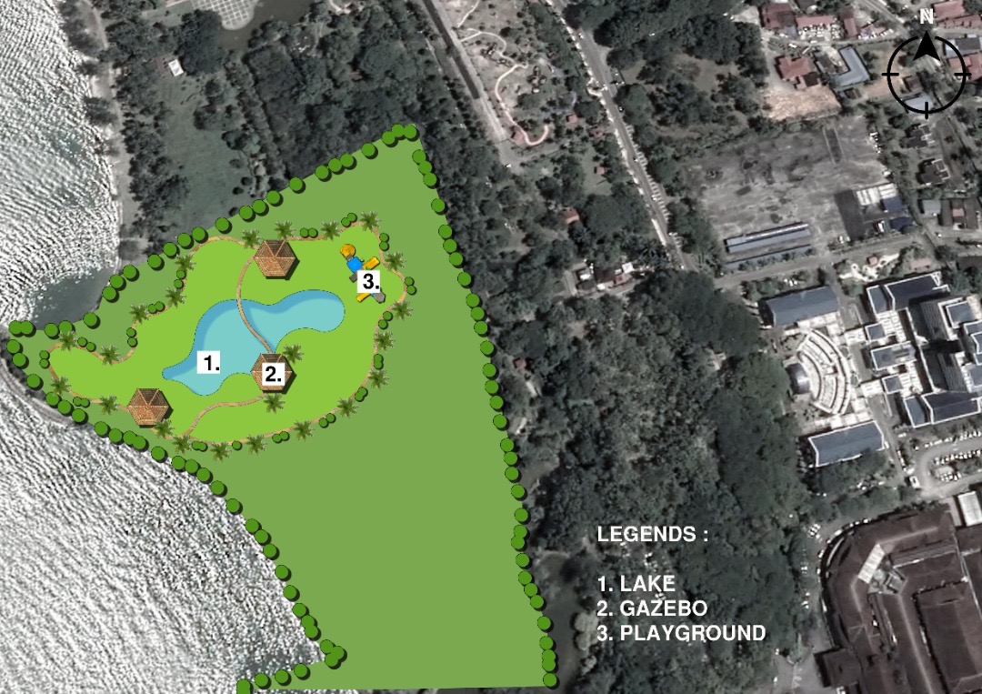
A new jogging track will be develop at Pekan Kuah which is besides the CHOGM Park. This would be the main park for local or tourist to jog or doing some recreation activities. Also provided the outdoor workout equipment for people doing some exercises and bench for people who just want to relax. This park are near to lake and beach. It's a perfect place to doing a recreation activities.
THE SCHEMATIC LAYOUT
There is four new land use component of our new development of tranquil linkages concept, which is residential, commercial, facilities and green area. the area for residential is 5.62 hectare, for commercial 3.34 hectare, facilities and infrastructure 1.50 hectare and last, the green area is 4.04 hectare.The total of our new development is 11.36 hectare.
DETAILED PROPOSED LAYOUT
Overall Detailed Layout
New Development
1. The proposed of housing
Characteristics of this proposed housing
1.Type: Low
cost terrace house
3.Total
area: 5.62 hectare
The total area for new development housing are 5.62 hectare including all those facilities, open space and the infrastructure. There is 201 unit of low cost terrace house with 20' X 60' of each size. Surau are provided in the residential area to make it easier for muslims to worship.
Every street in this residential area is filled and adorned with a soft landscape as a decoration in a residential area in order to create a harmony environment. infrastructure that will provided to this residential area is water tank, sewerage treatment plant and electric substation based on the guideline.
2. The proposed of clubhouse
Characteristics of this proposed clubhouse
1.Type: High Class Clubhouse
2.Total
area: 3.34 hectare
3.Total unit: 6
Clubhouse
An affordable high class clubhouse. The total area of this clubhouse is 3.34 hectare. There are 6 clubhouses located near on the beach. People can doing all those activities provide while enjoying the scenery of the beach.
All of these clubhouses provide different activities. Among the activities provided are swimming in the pool, horseback riding, movie watching and more. There is also a cafe serving a variety of dishes for breakfast, lunch, high tea and dinner. It also provides a rental space for organizing events or events such as anniversaries and weddings or company annual dinners.
3. The proposed of parking
Characteristics of this proposed parking area
2.Total
area: 1.50 hectare
This green parking area are 1.50 hectare and have 394 unit of parking provided. The new parking space are located opposite to the jetty Pekan Kuah in order to link the parking space with the jetty so that people can walk by if they want to park here. Surrounding with green things, and a lot of trees nor flowers, this parking space will provided more comfortable and more spacious space. This proposed parking will reduce the traffic congestion at Jetty Pekan Kuah.
The Masterplan
2. Parking area
3. Clubhouse
4. Jogging park
5. Residential area
REFERENCE
Zhao, J., &
Künzli, O. (2016). An introduction to connectivity concept and an example of
physical connectivity evaluation for underground space. Tunnelling and Underground
Space Technology, 55, 205-213. https://www.sciencedirect.com/science/article/abs/pii/S0886779815300870
Randall, T. A.,
& Baetz, B. W. (2001). Evaluating pedestrian connectivity for suburban
sustainability. Journal of Urban Planning and Development, 127(1), 1-15. https://ascelibrary.org/doi/abs/10.1061/(ASCE)0733-9488(2001)127:1(1)casa_token=8UqIRruut4QAAAAA%3AVVAYhrhp_aRWKOPm3__V7XUj1ZH7wDUY8kHXrgAc0W4IGKimalfeGBaEYD1Uo5WlXTBcBond9tg&


No comments:
Post a Comment