Introduction
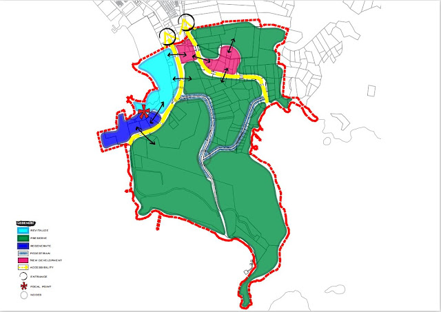
Elastica in Spanish language or elastic or also known as resilience means the phenomenon of positive adjustment in children and adolescents despite various adverse life events and traumatic events. Resilience emphasizes the importance (relevance) of positive factors and mechanisms for the development of children and adolescents. This Urban Elastica of Kuah has been selected for making the city of Kuah more liveable, sustainable and elastic, so be prepared for the new challenges ahead.
Vision
Kuah as an Elastica City in 2035.
Goal
To enhance the resilience, safety and quality of life in Kuah.
Objectives
- To strengthen the commercial and tourism functions of Kuah town.
- To apply resilient city concept in terms of infrastructure and environment to ensure continuous security.
- To restore dilapidated areas, build exciting new urban attractions and improve public facilities.
Bubble Theory
a) Density, Diversity and Mix
Resilient Cities will need to embrace density,
diversity and mix uses, users, building types and public spaces. Maximize the
active use of space and land are required in creating resiliency and reducing
the carbon footprint of urban development.
b) Transit
Supportive
The
most sustainable mode of transportation is transit. Resilient cities need to
re-orient their way of thinking by shifting from car oriented urban patterns to
transit oriented urban patterns and development.
c) Resilient Operation
A compact, mixed-use urban environment by contrast
is far more efficient in its demand for municipal services and infrastructure
requirements. Resilient cities will not subsidize inefficient forms of
development and instead prioritize city patterns and built forms that have a
reduced footprint on the environment and reduced burden on municipal resources
directing growth to where service exist.
d) Pedestrians
First
Resilient cities prioritize walking as the preferred mode of travel and as a defining component of a healthy quality life. Reducing car-dependency is a key objective and imperative. The alternative modes of transportation like walking, cycling and transit is more sustainable urban environments and improved quality of life. The cities that have prioritized walking that have created desirable location to live, work, play, and invest in.
Bubble Diagram
Issues and findings (zone 1)
i. Number of parking lot that has been proposed are not sufficient and cause people to park their car at the restricted area.
ii. Lack of parking at Jetty Kuah also lead to traffic congestion.
iii. Pedestrian walkways are not fully connected and there are cracks on some sections of the pedestrian paths.
iv. Taman Lagenda has no charm that attracts visitors.
v. Dataran Lang lack of shade trees and make the surrounding area quite hot
Development Strategies
Strategy 1 (Jetty Point)
- Proposed a multi level automatic parking same as Jalan Batas Kuala Terengganu for rental car at the existing parking where at the eagle square park and it will be charge for RM2.00 for the first hour and every hour later for RM1.00. With the existence of parking lot like this it solves parking problems especially in the jetty point area which is very crowded with vehicles for rent and makes it difficult for visitors to park at that area. One set of this automatic parking can fit to 10 cars. This automatic parking additionally saves space, it also provides the driver with ease in which he saves time and safety of the driver who wants to park. Especially for women, they do not have to using a lift or stairs to walk for a long distances because the parking lot is at one place.This proposed area may cover for a total area is 0.66 acre.
- The existing road for pick up and drop off passengers will be proposed for squares spaces where visitors can enjoy the view around the jetty and provide ample space for visitors to wait for rental cars at the square space. This road will be closed with a bollards for any vehicle to make it a safety square for visitors. This proposed area may cover 0.44 acre.
- Proposed to relocate the road for pick up and drop off passengers on the road facing the ticket counter next to the existing car park. In addition, it provides a convenient way for taxis and regular vehicles for pick up and drop off passengers. This is because to resolve any traffic jams that may occur.
Strategy 2 (Taman Lagenda)
Parks and recreation are resources and services provided for recreation, entertainment, and recreation purposes. Resources may be public spaces and amenities such as parks, nature reserves, open spaces, green roads, trails, and structures for sports, recreation, or arts programs.
This proposed park at the Taman Lagenda for local people and to attract more tourists for generating the economy. It may take cover for a total area is 8.06 acre.
- Proposed an outdoor gym combine with playgrounds for local people and tourist to fill their leisure time in making a healthy lifestyle within local people and tourists. This proposed is useful for all ages level and parents can see their kids play in the playground as they work out.
 |
Figure show perspective view for outdoor gym Source : pinterest.com https://www.pinterest.com/pin/31032684912644705/ |
- Apply the theme park of Takada in Japan, this proposed plan can resolve the problem in Taman Lagenda which is a bit bored and lack of charm as a recreational park towards tourists and local people. Therefore with the proposed plan here can make more attraction to tourists and local people in generating the economy for this city.
Figure show perspective view for purposed Taman Lagenda
Source : JapanAllPass
- Planting a new tree that act as a shelter for visitors, prevents strong winds from the sea, to incorporate elements such as the Japanese Takeda theme park and act as a decoration tree. Among the trees that have been mention is as below:
- Apply the style of Avatar Secret Garden in Penang theme park which is have a light hanging from the tree. So, there will make Taman Lagenda will be more functional at night to attract visitors with the many kind of light.
Figure show perspective view proposed of Taman Lagenda during nights
Source : SASMalaysia tour & travel
http://kh76872-sas-malaysia-tours-travel-sdn-bhd.yp.com.kh/products/184964-avatar-secret-garden
Strategy 3 (Dataran Lang)
- Also known as Eagle Square, Dataran Lang is one of Langkawi’s best known manmade attractions, a large sculpture of an eagle poised to take flight but in this area we can see it have a lack of green scenery and cause the area to get a little bit hot. So, here we proposed to add a green scenery even more around the Dataran Lang area which planting some types of trees such as shade trees, to make the area more dim and more comfortable for visitors but planted trees will not interfere with the eagle's sculpture because in this area the eagle sculpture is the main attraction for visitors.
 |
Figure show existing Dataran Lang view Source : google maps https://www.google.com.my/maps/@6.3082435,99.8511274,423m/data=!3m1!1e3 |
 |
Figure show perspective proposed of green scenery for Dataran Lang Source : landscape architecture, long island city, new developments |
Strategy 4 (New Development)
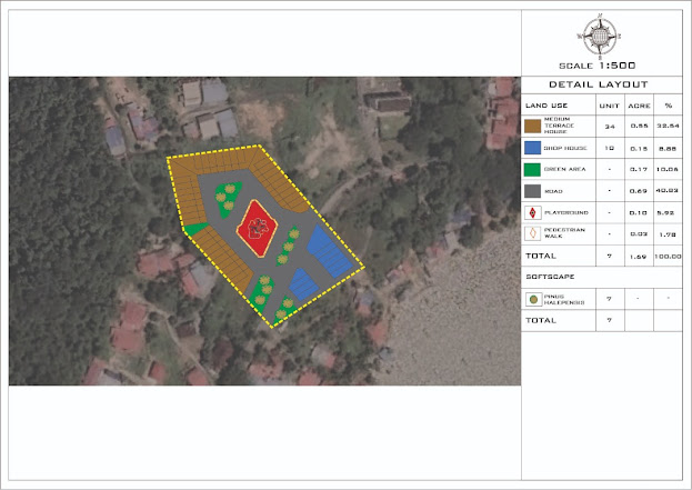
- Proposed for a affordable housing refers to housing units that are affordable by that section of society whose income is below the median household income. This new project is to propose affordable housing for M40 as a project that can generate economy and increase population at Kuah town center. This proposed plan which is terraced house 2 storey that will proposed at zone 1 which is at jalan penarak near to police quarters. The another area for the affordable housing are provided with the open space area for kids to play with the playground provided. It is intended to create a proper housing by following the guidelines set for the residential area. It may cover 12.7 acre for a total.
Guideline provided for 2 storey terraced house :
Minimum lot size : 20’ X 70’
Maximum Storey : 3 Storey
Set Back = 10’
Service road = 40’
Back Lane = 20’
Corner Cut = 50’ X 50’
Open Space = 10%
Source : Garis Panduan perancangan perumahan, JPBD Semenanjung Malaysia
Figure show perspective view proposed of affordable housing
Source : TBR residensi
- Proposed for a retail shophouse at Jalan Lencongan Putra 1 and some area along the Jalan Penarak in making a proper retail shophouses in zone 1, it will proposed with 2 types of shophouses which is single storey and double storey shophouses because besides of the proposed area have a unorganized business, so they can better run the business in a proper ways by renting a proposed shophouse. Shophouse is the premise of a trade carry out activities business and services specialty such as a bookstore, grocery stores, eateries, bakeries, laundry and more.
Guideline provided for 2 storey shophouse :
Minimum lot size : 20’ X 70’
Maximum Storey : 2 Storey
Service road = 50’
Back Lane = 30’
Corner Cut = 50’ X 50’
Source : Garis Panduan Perancangan Kawasan Perdagangan, JPBD Semenanjung Malaysia
Figure show perspective view proposed of 2 storey shophouse
Source : wasa development
Figure show perspective view proposed of single storey shophouse
Source : pasdec
http://www.pasdec.com.my/properties/shop-office-single-storey/
Figure show perspective view proposed of pedestrian walkways
Source : Kwuntong business area
Schematic Plan
Detailed Layout
- Strategy 1 (Jetty Point)
Master Plan
References
- JPBD Semenanjung Malaysia (2002), Garis Panduan dan Piawaian Perancangan Tempat Letak Kereta
- JPBD Semenanjung Malaysia (2016), Garis Panduan Perancangan Perumahan
- JPBD Semenanjung Malaysia (2016), Garis Panduan Perancangan Kawasan Perdagangan
- Resilient Cities: A systematic for developing cross sectoral change. Rocco Papa, TeMA Journal of Land Use Mobility (2015)


No comments:
Post a Comment